Thompson-Lundmark Mine Remediation Project
Learn about the work that has been done and what is ahead for the Thompson-Lundmark Mine Remediation Project.
On this page
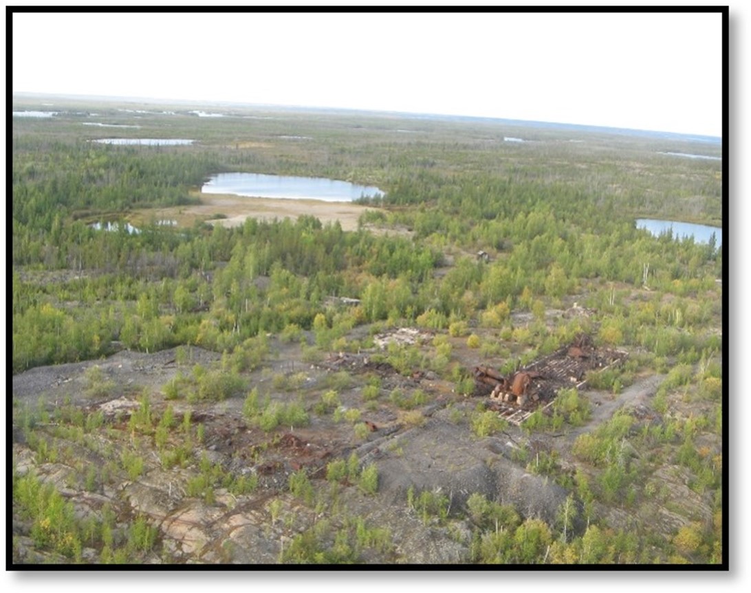
Accessible Text for The Thompson-Lundmark main mine site
Aerial view of forest, rock and mill building ruins with a lake and tailings in the background.
Overview
The Thompson-Lundmark Mine is a former gold and silver mine located 48 kilometres northeast of Yellowknife on the shores of Thompson Lake. Mineral exploration first occurred in the late 1930s and the Cominco-operated mine went into full production in 1940. In 1943, operations ceased due to a lack of human resources and funding during World War 2 and did not resume until 1946. Later in its operation, the site was powered by a 33,000 volt, 40 kilometre powerline from the Bluefish power station.
Operations at the site resulted in:
- 122,281 tonnes of ore being processed
- 65,347 ounces of gold being recovered
- 12,814 ounces of silver being recovered
Although most of the physical buildings were destroyed in a forest fire in 1998, environmental concerns remain at the site.
Prior to the fire, buildings on site included:
- 2-story bunk house (capacity for 50 people)
- cook house
- commissary
- 3 steam-heated apartment houses
- 3-bed hospital
- curling rink
- warehouse
- staff quarters
- headframe and shaft house
- mill building
- boiler house
- refinery and assay
- garage
- power and hoist building
- steel shop
- blacksmith shop
- machine shop
- carpenter shop
There are also at least 5 known waste dumps related to the site, and 2 cabins north of Treasure Island (with a small dump site).
Project goals
The Thompson-Lundmark Mine Remediation Project goals include:
- using approaches that are cost-effective and risk-based
- restoring the land using industry best practices of:
- Traditional Knowledge
- science
- engineering
- working with Indigenous rights holders in all project stages to:
- build positive relationships and trust
- protect traditional lands and water
- planning for effective closure and monitoring, including community involvement in monitoring where warranted
Issues at the site
Concerns at the Thompson-Lundmark Mine site include:
- physical hazards such as:
- mine shafts
- headframe
- mine openings
- debris
- ruins of the burned or dilapidated structures
- chemical hazards such as:
- contaminated (hydrocarbon-impacted) soils and sediments
- tailings in the Chum Lake Tailings Containment Area and Thompson Lake
- waste rock
- asbestos
Approximately 15 hectares in size, the remediation site will include the clean-up of:
- mine site on the eastern arm of Thompson Lake
- Chum Lake Tailings Containment Area
- dumps
- 5 mine shafts
- Kim shaft (1)
- Fraser shaft (2)
- Treasure Island shaft (2)
The Treasure Island shaft is located on an island with a constructed causeway made of waste rock, with part of the mine opening currently underwater. There are also 2 cabin ruins and a dump located across from Treasure Island that will be cleaned up and removed.
Chum Lake flows through 2 wetland/ponds and into Thompson Lake, while Thompson Lake flows 2.5 kilometers through a series of smaller lakes and wetlands into Hidden Lake. Data collected as part of the Phase III Environmental Site Assessment conducted in 2022 will clarify whether these areas have become contaminated and will require remediation.
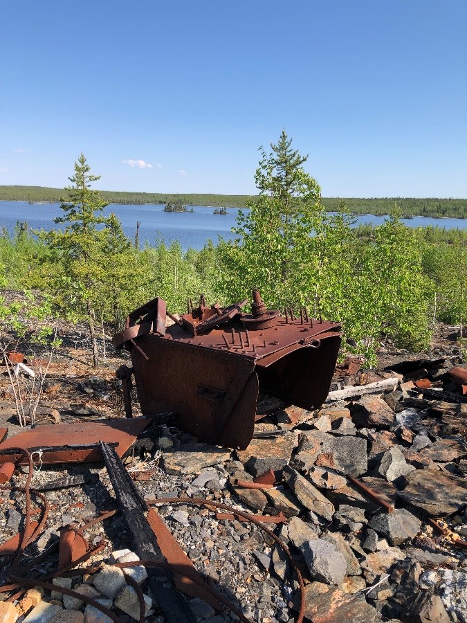
Text alternative for A rusted cart and debris on the main Thompson-Lundmark Mine site
Rusted mining debris is visible on rocks, with trees growing behind. A lake is visible in the background.
Engagement approach
The Thompson-Lundmark Mine Remediation Project actively engages Indigenous communities. This is done by providing regular project updates through virtual community meetings (during COVID restrictions) and hosting Traditional Knowledge workshops with community leaders and representatives.
If it is safe to do so, and following all guidance on COVID-prevention protocols, the project team will aim to bring Elders and community representatives from the Yellowknives Dene First Nation and the North Slave Métis Alliance to the site to survey the area and provide recommendations to the project team. The insight they provide is invaluable to the Government of Canada when making decisions about how to clean up the mine site area for the safety of Northerners and the environment.
Work done to date
2022
The Phase III Environmental Site Assessment commenced:
- further brush clearing to allow access for assessment work
- installation of a floating dock to improve access and safety
- field investigation and sampling completed for:
- soil
- vegetation
- water
- fish
- benthic invertebrates
A final assessment report is expected in early 2023.
2021
The remediation project team made preparations to enter into the Phase III Environmental Site Assessment stage. Assessment activities included:
- brush clearing on paths and roadways around the project site
- Traditional Knowledge survey and study of the area
- site-wide hazard assessment to identify existing site hazards at the site and recommended mitigations
- gap assessment to identify where additional information or work was required
- Archaeological Overview Assessment
- Terrain and Logistics Analysis
2014-2020
The project remediation timeline had not yet been established.
2012-2013
A Phase II Environmental Site Assessment was completed in 2013 after a field investigation was conducted in August 2012. The focus of this assessment was to identify contaminant sources and assess the soil, sediment, and surface water quality. A qualitative assessment of waste sites was also completed and allowed for the development of more accurate maps of the area.
The Environmental Site Assessment built on the 13 areas of potential concern identified in 2007 and further broke them out into 18 areas of environmental concern. The Project collected 32 soil samples, as well as 2 vegetation samples (for metals) and 4 building material samples.
2007
A Phase I Environmental Site Assessment was completed in 2007 after a field investigation was conducted in August 2006. The assessment identified 13 areas of potential concern and identified a 40 km power line from Bluefish to Thompson Lake. The Project removed 8 kilometres of power line poles between Thompson Lake and Sparrow Lake.
What's next
In 2023, the results of the 2022 Phase III Environmental Site Assessment will better define the extent of the contamination at site with its baseline information about:
- water
- sediment
- soil
- vegetation
- fish tissue
- benthic invertebrates
The project team will be conducting further assessments in 2023, such as:
- Human Health and Ecological Risk Assessment, Remedial Options Analysis, and Archeological Impact Assessment
- Powerline Removal Program and an Asbestos Abatement Program
All of this will inform what goes into the Remedial Action Plan, which will determine the path forward for the remediation project team.
Other upcoming work includes:
- improving the signage currently at site
- determining the amount of hazardous and non-hazardous waste, waste rock and tailings
- brush clearing and other care and maintenance tasks
The next few years will see the project team further engaging with the Yellowknives Dene First Nation and North Slave Métis Alliance as planning for future remediation activities increases.