Archived - 1996-1997 Annual Report of the Implementation Committee Sahtu Dene and Metis Comprehensive Land Claim Agreement
Archived information
This Web page has been archived on the Web. Archived information is provided for reference, research or record keeping purposes. It is not subject to the Government of Canada Web Standards and has not been altered or updated since it was archived. Please contact us to request a format other than those available.
Author:Minister of Indian Affairs and Northern Development
Date:Ottawa, 1998
ISBN:0-662-63319-9
QS-5334-003-BB-A1
PDF Version
(532 Kb, 22 Pages)
Table of Contents
- Foreword
- 1. Features of the Sahtu Dene and Metis Comprehensive Land Claim Agreement
- 2. Highlights
- 3. Implementation Committee
- 4. Implementing Bodies
- 5. Sahtu Secretariat Incorporated (SSI)
- 6. Government of the Northwest Territories
- 7. Government of Canada
- Appendix 1: Membership of Implementing Bodies (as of March 31, 1997)
- Appendix 2: Map of Sahtu Settlement Area
- Appendix 3: Schedule of Capital Transfer Payment, 1994 to 1996
- Appendix 4: Implementation Payments, 1994-1995 to 1996-1997
Foreword
The Implementation Committee, whose role is to monitor and direct the implementation of the Sahtu Dene and Metis Comprehensive Land Claim Agreement, is comprised of a senior official from each of the parties: the Sahtu Secretariat Incorporated, the Government of the Northwest Territories and the Government of Canada. As members of the Implementation Committee, we are pleased to provide the third annual report on implementation of the Sahtu Dene and Metis Comprehensive Land Claim Agreement. One of our monitoring responsibilities is the preparation of this annual public report from information provided by various departments within the federal and territorial governments, the Sahtu Secretariat Incorporated and the other bodies established under the Agreement. This report covers the 1996-1997 fiscal year from April 1, 1996 to March 31, 1997.
The Implementation Committee functions by consensus and serves as a forum where parties to the Agreement can raise issues and voice their concerns.
New partnerships are being put in place based on the settlement of Aboriginal land claims and the establishment of future self-government agreements in an atmosphere of mutual respect and recognition of rights. The Implementation Committee is firmly committed to strengthening this partnership by ensuring that the panics continue to fulfil their responsibilities under the Agreement, and it is confident that progress will continue in a spirit of co-operation.

1. Features of the Sahtu Dene and Metis Comprehensive Land Claim Agreement
In July 1993, the Sahtu Dene and Metis voted to approve the Sahtu Dene and Metis Comprehensive Land Claim Agreement. After being approved by the territorial and federal governments, the Agreement was signed on September 6, 1993, in Tulita (formerly Fort Norman). The Sahtu Dene and Metis Land Claim Settlement Act came into effect on June 23,1994.
Under the Agreement, the Sahtu Dene and Metis received title to 41,437 square kilometres of land in the Northwest Territories, an area slightly larger than Vancouver Island. Subsurface rights are included on 1,813 square kilometres of this land.
The Sahtu Dene and Metis will receive financial payments totalling $75 million (in 1990 dollars) over a 15-year period, as well as a share of the resource royalties paid to governments each year in the Mackenzie Valley.
The Agreement confirms the right of the Sahtu Dene and Metis to hunt and fish throughout the Sahtu Settlement Area. It also gives them the exclusive right to trap in the Sahtu Settlement Area.
The Agreement provides for guaranteed participation by the Sahtu Dene and Metis in institutions of public government for renewable resource management, land use planning and land and water use within the Sahtu Settlement Area, and for environmental impact assessment and review within the Mackenzie Valley.
The Agreement also provides for the negotiation.
2. Highlights
- The Sahtu Secretariat Incorporated (SSI) received the fourth transfer payment in the amount of $6,640,076 (net of negotiation loans repayment) on September 6, 1996, which is the anniversary of the signing of the Sahtu Dene and Metis Comprehensive Land Claim Agreement.
- An annual total of $311,491 was paid to the SSI for resource royalties on a quarterly basis.
- The Implementation Committee established the Land and Water Working Group which held its first meeting in November 1996 and identified tasks for immediate attention.
- The Enrolment Board published the 1996 Enrolment Registry listing 2,288 beneficiaries covered by the Agreement.
- The Sahtu Renewable Resources Board hired an executive director, completed board membership and opened a temporary office in Norman Wells.
- The Joint Working Group on Sahtu Heritage Places and Sites met in January 1997 to agree on guidelines for heritage sites, and is now preparing recommendations to present to the Minister.
3. Implementation Committee
The Implementation Committee is comprised of three senior officials: one representing the Sahtu Secretariat Incorporated (SSI), one representing the Government of the Northwest Territories (GNWT) and one representing the Government of Canada, the responsibilities of the Committee, which makes decisions by consensus, include the following:
- overseeing and directing the implementation of the Agreement in accordance with the implementation plan;
- adjusting the schedule for carrying out implementation activities, reallocating resources and amending the implementation plan as required;
- addressing disputes arising between the parties; and
- preparing a public annual report on the implementation of the Agreement,
Committee members are Danny Yakeleya, SSI; Mark Warren, Director, Claims Negotiation and Implementation, Ministry of Aboriginal Affairs, GNWT; and Terry Henderson, Director General, Claims Implementation, Department of Indian Affairs and Northern Development (DIAND).
During 1996-1997, the Implementation Committee dealt with various issues, including the following:
- establishing the Land and Water Working Group;
- funding of implementation bodies; and
- overseeing the production of the 1995-1996 annual report of the implementation Committee.
4. Implementing Bodies
The Agreement includes provisions to put in place various implementing bodies to determine who meets the qualifications to enrol as a beneficiary of the Agreement, manage wildlife resources, plan and regulate land and water use, settle disputes that may arise in the interpretation of the Agreement and conduct both environmental impact assessments and reviews of development proposals. The membership, functions, and time frame for the establishment of each of these bodies are also specified in the Agreement.
The Enrolment Board, the Arbitration Panel and the Renewable Resources Board have been established. The membership of these implementing bodies is listed in Appendix 1, Prospective members of the Mackenzie Valley Environmental Impact Review Board have been identified, and the Joint Working Group on Sahtu Heritage Places and Sites has also been established.
The Sahtu Land Use Planning Board, the Sahtu Land and Water Board and the Mackenzie Valley Environmental Impact Review Board will be established on enactment of the proposed Mackenzie Valley resource management legislation. The Surface Rights Board will be established after separate federal legislation is passed. A Mackenzie Valley Land and Water Board will also be established pursuant to Bill C-80, the proposed Mackenzie Valley resource management legislation.
4.1 Enrolment Board
The Enrolment Board has seven Sahtu Secretariat Incorporated (SSI) appointees and two Government of Canada appointees. The chairperson is Lorraine Doctor and the vicechairperson is Wilfred McNeely, Jr.
In 1996-1997, the directors selected an Enrolment Board executive committee comprised of the chairperson, the vice-chairperson and the enrolment coordinator. In 1996-1997, the Board held six meetings and the Executive Committee held two additional meetings. Board members approved or rejected enrolment applications submitted under Section 4,2 of the Agreement. As of March 31, 1997, the Board had enrolled 2,312 beneficiaries. The Board published the 1996 Enrolment Registry listing 2,288 eligible beneficiaries covered by the Agreement. The Registry has been distributed to all land corporations in the Sahtu region. The Board also reviewed monthly expenditures and activity reports, and developed work plans to fulfil its mandate.
The Board adopted an extensive advertising campaign within the Sahtu Settlement Area (SSA) by placing advertisements in newspapers, distributing posters throughout the Sahtu region and offering a toll-free telephone line. There was a positive response to the advertisements. The free telephone line allowed applicants to acquire information readily and enabled Board members to maintain regular contact with the office. Enrolment kits providing information, application forms and prepaid return envelopes allowed individuals to notify the Board of other potential beneficiaries. The Board gathered church records from the last century and used them to complete family histories. The computer data base is now complete, with all the information received from applicants.
As required by Section 4.4.2 (j) of the Agreement, the Board provides an enrolment certificate and a photo identification card to each beneficiary as proof of enrolment. Applicants living within the Sahtu region have their photographs taken in their communities by Board staff, while applicants outside the region are required to send identification information and a photograph to the Board office for processing.
4.2 Arbitration Panel
In its second year of operation, the Sahtu Dene and Metis Arbitration Panel completed its internal administrative procedures and signed a funding agreement with the federal government, The Panel also reviewed national and international processes for instituting arbitration proceedings and adopted rules of procedure by which persons could obtain arbitration under the Land Claim Agreement. The rules, called the Arbitration (Commencement of Proceedings) Rules, were adopted by the Panel on August 1, 1996.
In September 1996, the Panel held an informative and productive three-day combined meeting and workshop in Norman Wells. During the workshop, the Panel heard about the culture and history of the Sahtu, learned about the geography and natural resources of the settlement area, and gained a better understanding of some of the challenges faced in implementing the Land Claim Agreement.
By prior agreement of the Arbitration Panel, the positions of chairperson and vicechairperson rotated in September 1996, with Larry Chartrand assuming the position of chairperson of the Panel and Deborah Hanly becoming vice-chairperson.
4.3 Renewable Resources Board
It is the responsibility of the Sahtu Renewable Resources Board (SRRB) and all other affected parties to protect, conserve and manage in a co-operative spirit all renewable resources within the Sahtu Settlement Area in a sustainable manner to meet the needs of the public today and for future generations.
The Board was established in January 1996. Activities during the first half of the fiscal year centred around hiring an executive director, finalizing Board membership and establishing temporary office headquarters in Norman Wells, Then the Board established communications and worked with adjacent claim-area resource hoards, territorial government resource departments and federal agencies involved in resource management.
The Board provided funding of almost $ 100,000 to outside research agencies. Major projects included support and expansion of a Geographic Information System (GIS) for the Sahtu region, an extensive aerial muskox survey of the North Shore District of Great Bear Lake and a satellite collaring project for Bluenose Caribou on their wintering range.
Five new staff members were added to the agency's complement by year-end: a GIS specialist, an office administrator, a research biologist, an integrated resource management specialist and a harvest study co-ordinator. All co-funded research projects were successfully completed within approved funding levels.
At the last Board meeting of the fiscal year, approximately $250,000 of co-funded renewable resource research-related studies were approved for the 1997-1998 year. Additionally, Board staff members plan to conduct a number of resources projects during the coming year and to continue working closely with all renewable resource agencies in the Mackenzie River system.
4.4 Joint Working Group on Sahtu Heritage Places and Sites
The Joint Working Croup met in January 1997 to agree to guidelines for the identification of heritage sites, and to draft a work plan to meet the requirements of Section 26 of the Sahtu Dene and Metis Comprehensive Land Claim Agreement. Funding was secured and field workers are now documenting the necessary information for the Joint Working Group to make its recommendations to the Minister. The Joint Working Group will meet in September 1997 to come to an agreement on its recommendations.
4.5 Mackenzie Valley Environmental Impact Review Working Group
The Mackenzie Valley Environmental Impact Review Board will be established as the principal agency to undertake environmental impact assessment and review in the Mackenzie Valley. This agency's jurisdiction will apply to all lands in the Western Arctic, excluding the Inuvialuit Settlement Region and Wood Buffalo National Park. The Board will be established under Bill C-80, the proposed Mackenzie Valley resource management legislation, in response to both the Sahtu Dene and Metis Comprehensive Land Claim Agreement and the Gwich'in Comprehensive Land Claim Agreement. The Board will have equal membership from nominees of First Nation groups and from government, not including the chairperson.
The Mackenzie Valley Environmental Impact Review Working Group, which was formed in 1995-1996, met for the first time in May 1996. The purpose of the Working Croup is to prepare for the creation of the Board and the draft legislation. When this act comes into effect, the Board can be established with the nominees appointed and can begin environmental impact assessment and review for the Mackenzie Valley.
During 1996-1997, the Working Group held six meetings. The Working Group and staff developed, in part, a draft communications strategy and related documents; initiated guidelines for preliminary screening and environmental assessment, including protocols; designed and held training sessions for the members; commenced office procedures and relocated its office within Yellowknife; hosted and attended public meetings to disseminate information and to build liaisons with other organizations; and worked to fulfil other implementation requirements, such as a Five-Year Review of the Gwich'in Implementation Plan.
4.6 Land and Water Working Group
On enactment of the proposed Mackenzie Valley resource management legislation, the Sahtu Land and Water Board will be established to regulate land and water use throughout the Sahtu Settlement Area. It will amend, issue or renew water licences, land use permits and other authorizations as described in Bill C-80, the proposed Mackenzie Valley resource management legislation and associated regulations. Preliminary to establishing the Board, the Land and Water Working Croup was formed in November 1996 to begin the preparatory work for the Sahtu Land and Water Board. This preparatory work was supported by a budget of $85,228.
The Working Group met initially for a workshop in fort Good Hope during November 1996 and received briefings on Bill C-80, the proposed Mackenzie Valley resource management legislation, the roles and responsibilities of board members, the environmental assessment process, and water licence and land use permit issues. Information about resource management procedures was gathered at subsequent meetings in Yellowknife in January and February 1997. In March 1997, one of the Board members attended a workshop on integrated resources management and land use planning in Inuvik. Another meeting of the Working Group was held during March 1997 in Norman Wells.
Tasks identified in the work plan of the Land and Water Board Working Group include the following:
- recruitment of staff;
- office set-up and operations;
- training for the Working Group and interim staff;
- efforts toward public consultations and awareness; and
- preparation of office manuals for policy, administration and procedures.
5. Sahtu Secretariat Incorporated (SSI)
The Sahtu Secretariat incorporated (SSI) was formed by the seven Sahtu land corporations (four band land corporations and three Metis land corporations) on June 23, 1994, when the Sahtu Dene and Metis Land Claims Settlement Act was enacted. The mandate of the SSI is to implement the Agreement and to deal with issues that concern the Sahtu Dene and Metis.
5.1 Board of Directors
In 1996-1997, the SSI Board of Directors was comprised of the following:
5.2 Head Office of the Sahtu Secretariat Incorporated
The head office is in the Chief George Kodakin Building in the community of Deline. The building also houses the Sahtu Dene Council, the Sahtu Enrolment Board and the Deline land and financial corporations.
5.3 Community Renewable Resources Councils
According to the Agreement, designated community organizations (land corporations) must appoint renewable resources councils for each community. In 1996-1997, the following renewable resources councils were active in the Sahtu Settlement Area:
- Colville Lake Renewable Resources Council
- Deline Renewable Resources Council
- Fort Good Hope Renewable Resources Council
- Tulita Renewable Resources Council
- Norman Wells Renewable Resources Council
Renewable resources councils encourage and promote local community involvement in conservation, harvesting studies of research and wildlife management, and advise the Sahtu Renewable Resources Board.
5.4 Land Ownership
The SSI does not own land. All the settlement lands are owned by the district land corporations in the three districts of Deline, Tulita and K'Asho Got'ine. In the Tulita district, the settlement lands are owned jointly by the Tulita Land Corporation, the Fort Norman Metis Land Corporation and the Ernie McDonald Land Corporation. In the K'Asho Got'ine district, the land is owned jointly by the Yamoga Land Corporation (Fort Good Hope Band), the Fort Good Hope Metis Local No. 54 Land Corporation and the Ayoni Keh Land Corporation (Colville Lake). The Deline Land Corporation owns all the land in the Deline district.
5.5 Sahtu Trust
The Sahtu Trust was created by the seven financial corporations which receive settlement monies and royalties under the terms of the Agreement. The Sahtu Trust is managed by the SSI on behalf of the financial corporations, and each financial corporation owns a portion of the Sahtu Trust as allocated on a per capita basis.
At December 31, 1996, the net capital invested in the Sahtu Trust was $25.2 million. The net income generated by the trust in 1996 was $2,888,257. This amount was distributed to the community financial corporations on a per capita basis.
5.6 Sahtu Dene and Metis Self-Government
Provisions relevant to self-government are contained in Chapter 5 and Appendix B of the Sahtu Dene and Metis Comprehensive Land Claim Agreement. The Agreement provides for the negotiation of self-government agreements which will be brought into effect through federal legislation.
5.7 Other Activities
The SSI is part of the Aboriginal Summit and, along with the Aboriginal Caucus, will present part one of the Western Territory constitution for consideration. Presently, Deline has taken the lead in negotiating the inherent right to self-government and is also recognized as a member of the Aboriginal Summit. The Chief Negotiator is Danny Caudet. Other communities will begin negotiations when they are ready.
Margaret McDonald is the Co-ordinator of the Regional Bilateral Program, which has a new office in Norman Wells. The annual budget for this year is $647.000. Training dollars are allocated by a committee comprising one member from each of the three districts and one member from SSI.
6. Government of the Northwest Territories
The Government of the Northwest Territories (GNWT) undertook to perform various implementation activities pursuant to the Sahtu Implementation Plan and related funding agreements, as described below.
6.1 Ministry of Aboriginal Affairs
During the period covered by the report, the Ministry co-ordinated GNWT implementation activities, including liaising with the Sahtu Secretariat Incorporated (SSI), federal and GNWT representatives; preparing status reports for the Implementation Committee; and preparing the GNWT component of this annual report.
A Ministry official actively participated in the three meetings held by the Implementation Committee. The Ministry met with the Arbitration Panel to discuss its rules and procedures and also worked with the Department of Justice to ensure that the registration of title to Sahtu lands continues. The Ministry provided advice and assistance to the Sahtu Renewable Resources Board (SRRB) . A Ministry official represented the GNWT on the working group which met during the past year to draft Bill C-80, the proposed Mackenzie Valley resource management legislation.
In accordance with Chapter 5 and Appendix B of the Agreement, the Ministry of Aboriginal Affairs also participated in the ongoing self-government negotiations with the community of Deline. A Process and Schedule Agreement outlining the approach to negotiations is expected to be ready for initialling by all three parties in July 1 997.
6.2 Resources, Wildlife and Economic Development
The Department of Resources, Wildlife and Economic Development (DRWED) was created in August 1996 by the merger of the following departments: Renewable Resources; Economic Development and Tourism; and Energy, Mines and Petroleum Resources. This Department has assumed responsibility for implementation activities formerly discharged by the merged departments.
Working in co-operation with the SRRB, an outline for a project was developed to meet the Geographic Information System (CIS) needs of the Sahtu Settlement Area for the next five years. The project was designed to be used and funded by all the SSA public government institutions. The project was presented to the SRRB which approved $60,000 for the 1996-1997 fiscal year. The project was also presented to the Sahtu Land and Water Working Group for its consideration. The necessary computer hardware and software for the project was bought and installed in the DRWED office in Norman Wells, and the GIS specialist began her work for the SRRB in February 1997. The GIS project is expected to be functional during the 1997-1998 fiscal year.
Work continued on summarizing the available harvest and biological information on the Bluenose Caribou to prepare a herd status report. Samples from hunter-killed animals that appeared to be abnormal were analysed for possible diseases or parasites. After diagnosis, information on the causes of the abnormalities was sent to hunters.
A draft management plan for the Bluenose Caribou herd was also prepared, and a workshop was held to present information on the herd as well as to review, and comment on, the draft plan. Participants at the workshop from the Sahtu region included the SRRB and the Sahtu Divisional Board of Education. A meeting of the chairpersons of the wildlife boards from the four settled land claims in the Northwest Territories started work on a cooperation agreement leading to a co-management agreement. An advisory committee will be established to review progress on the development of the management plan and to recommend a final version.
An aerial survey of the SSA to estimate the number of muskox north of Great Bear Lake was jointly funded by the SRRB and the Department's Sahtu region. The aim was to obtain the first estimate of muskox population numbers and their distribution since the last study, which was conducted in 1987. The study began on March 10, 1997, and was completed on March 27, 1997. The average density of muskox within the study area was determined to be 32 per 100 square kilometres and the population was estimated at 1779. Muskox were classified as either adults or calves (less than one year old). The study estimated that approximately 15 percent of all muskox observed were calves. The results of the study may be used by the SRRB and the GNWT to adjust the annual quota for muskox within the SSA and the distribution of tags among the Sahtu communities and resident hunters.
The Department worked in close co-operation and consultation with the Sahtu District Land Corporations and each individual Sahtu community to support the shared objective of encouraging employment opportunities and economic self-sufficiency within the SSA. The Department provided support to help Sahtu businesses and individuals obtain financing from its programs and from other government and private financing sources. The Department has also consulted with the SSI on the creation of a tourism development strategy for the settlement area. Work continued on the implementation of the community economic development planning process which was introduced to the Sahtu communities in 1994-1995.
The Canol Trail and Dodo Canyon Territorial Park steering committee continues to work on the park master plan. The mandate of the committee is to prepare the park management plan by July 1997. The management plan will be complete with maps, site plans, construction and employment requirements, and environmental research for review and approval by the federal government. The Department held meetings dealing with the development of the park management plan in both Norman Wells and Tulita.
A joint effort of the federal and territorial governments in co-operation with the community of Deline is being considered as a means of protecting cultural resources at Grizzly Bear Mountain and the Scented Crass Hills.
6.3 Education, Culture and Employment
A representative of the Department's Culture and Heritage Division is the GNWTs nominee on the joint Heritage Working Group, This Working Group is responsible for reviewing Sahtu heritage places and sites and making recommendations to the appropriate Minister, and has developed a community-based research project to gather information on heritage sites which will be funded by the Department during the 1997-1998 fiscal year.
The Department continues to review land use permit applications from the Sahtu area for their possible impact on historic resources. Major Canadian and international museums and archival institutions were contacted for information on relevant items in their collections. A report on this search was finished on March 31, 1997.
6.4 Justice
The Department of justice continued to participate in the ongoing implementation of the Agreement. Legal advice and assistance was provided to a number of GNWT departments, including the Department of Resources, Wildlife and Economic Development; the Department of Municipal and Community Affairs; and the Ministry of Aboriginal Affairs on a variety of issues including resource royalties, self-government and wildlife. Work began on amendments to the Wildlife Act to recognize and implement the Agreement.
The Legal and the Legislative divisions participated in meetings to review the proposed Mackenzie Valley resource management legislation. Staff of the legislative Division provided the French version of an early draft of the regulations.
The Land Titles Office has now issued certificates of title to almost all the surveyed municipal parcels. A number of surveys have also been registered for the specific sites and portions of the boundaries of the large settlement land parcels. Certificates of title will be issued on the request of the Sahtu. In total, certificates of title have been issued for 79 of the Sahtu-owned parcels.
6.5 Public Works and Services
The Department negotiated two contracts for $211,727 with Sahtu Contractors Ltd., for the bulk fuel resupply of all Sahtu communities (Deline, Fort Good Hope, Colville Lake and Tulita) except Norman Wells. The two-year contracts were awarded on November 21, 1996.
7. Government of Canada
7.1 Economic Activity and Employment
Funding was provided to the Sahtu Secretariat Incorporated (SSI) for a labour market analysis and training needs evaluation within the oil and gas in dustry to refine strategies for employment and training of Sahtu residents in the oil and gas sector.
The Tulita Band received $40.000 from the Resource Access Negotiations program to negotiable impact benefits agreements and access agreements with two oil companies and one seismic company. The agreements were negotiated on behalf of the Tulita district which includes the Tulita Land Corporation, Fort Norman Metis Land Corporation and Ernie MacDonald land Corporation.
Public Works and Government Services Canada (PWGSC) continues to inform the various Sahtu land claimant groups of contracting opportunities which arise in their settlement area. PWGSC also offers seminars to familiarize companies with the use of its bidding system and how to do business with the federal government.
7.2 Environmental and Wildlife Management Issues
The Department of Indian Affairs and Northern Development (DIAND) carried out consultations with ail Sahtu communities before issuing oil and gas exploration rights in the region. As well, following Chapter 9 of the Sahtu Final Agreement, discussions were held with the SSI on the Norman Wells Proven Area Agreement with Esso Resources.
Sahtu agencies participated with DIAND in an environmental audit of the Sawmill Bay waste site in preparation for the clean-up scheduled for the following summer. A management committee consisting of Sahtu organizations and government was initiated to oversee the clean-up and disposal of radioactive and other wastes associated with the site.
Work initiated the previous year on toxicity studies of effluent in the Mackenzie River downstream of the Norman Wells area continued this year. The work was undertaken in response to concerns expressed by Sahtu residents. Laboratory analysis of sampling products is presently under way.
The Canadian Wildlife Service (CWS) advised the Sahtu Renewable Resources Board (SRRB) of all changes to migratory bird regulations that may have an impact on the Sahtu Dene and Metis.The SRRB is aware that migratory birds are managed according to a welldefined set of regulations. CWS has regularly advised the SRRB about changes to the Migratory Bird Regulations such as the use of non-toxic bird shot and the proposed spring hunting season.
The SRRB receives annual migratory bird harvest statistics compiled by CWS and the Linked States Fish and Wildlife Service. Using these statistics, the SRRB is conducting a harvest study which will provide the basis for establishing total allowable harvest of migratory birds in the Settlement Area.
The CWS sits on the Arctic Goose Working Group of the Arctic Goose Joint Venture. The Joint Venture is a co-operative Canada-United Slates body that co-ordinates goose management and research in both countries. This group deals with the overpopulation of snow geese in the Arctic, especially in the Central Arctic. Sahtu Dene and Metis harvest snow geese from the Western Arctic population where the problem does not appear to be so severe. The SRRB, however, is kept informed about this issue. Canada through the CWS, initiated negotiations with the United States to amend the Migratory Birds Convention to allow for the spring hunting of waterfowl by northern Aboriginals including the Sahtu.The CWS has informed the SRRB about the progress of these negotiations.
The CWS is involved in the preparation of management plans for the Bluenose Caribou herd and Barren-Ground grizzly bears, both of which move in and out of the Sahtu Settlement Area, CWS also sits on the Porcupine Caribou Management Board.
7.3 Heritage Issues
Section 17.3 of the Agreement provides for establishment of a territorial park that is to include a narrow corridor along the Canol Trail and a larger node in the scenic Dodo Canyon area, 40 kilometres southwest of Norman Wells.
The Canol (short for Canada Oil) Trail follows the access road for the pipeline built during World War II to carry oil from Norman Wells southwest to Whitehorse on the Alaska Highway Much of the pipeline route, in turn, followed trails used traditionally by the Mountain Dene. The Trail was designated a national historic site in 1983, and a plaque was placed on the Northwest Territories' side of the Trail in October 1996. The NWT segment of the Trail runs 355 kilometres from the Mackenzie River to MacMillan Pass on the Yukon border, traversing the impressive wilderness terrain of the Mackenzie Mountains.
In 1996-1997, the Management Planning Committee held several planning and community meetings and also circulated a public newsletter. Key issues to be resolved are how to balance historical and environmental concerns and whether development efforts should be spread along the entire trail or concentrated at key points such as Dodo Canyon.
In the summer of 1996, Parks Canada conducted the second year of an archaeological survey at Great Bear Lake as provided for by Section 26.4.3 of the Agreement. To supplement work done in 1995, 51 previously unrecorded sites were mapped and recorded, and three known sites were revisited. Elders from Deline were interviewed about Dene place names. legends, stories and the significance of numerous locations identified through the project.
Researchers made a number of valuable discoveries including early projectile forms, isolated graves, historic cabins, birchbark canoe remains and numerous camps with associated tipi and log shelter remains. The Mackintosh Bay and Douglas Bay areas of Scented Grass Hills stand out as places that were heavily used for several thousand years by Sahtu Dene and Metis and their ancestors.
The 1825-1826 wintering place of Sir John Franklin's Second Expedition in the community of Reline has been a point of interest for Dene for decades. Since the late 1980s, the community and the Prince of Wales Northern Heritage Centre have worked closely together to protect the remains of Old Fort Franklin. The importance that the Dene assigned to the old site led to its inclusion as one of the six heritage sites identified in the Agreement. In 1995, Parks Canada began working with the community of Deline to explore the national significance of Old Fort Franklin. A major part of the project was the collection of oral histories and archival information documenting the role of the Dene in the Second Expedition.
The Historic Sites and Monuments Board of Canada recommended to the Minister of Canadian Heritage that Old Fort Franklin be designated a national historic site. The Minister, in December 1996, advised the community of Deline that "the traditional Dene fishery at Deline, its use over time and the long history of sharing its resources, as well as the remains of Fort Franklin, the wintering quarters of Sir John Franklin's Second Expedition, are of national historic significance and should be the subject of a joint commemoration." In 1997, the parties will consider the best means of presenting this information.
Options for cultural heritage protection of Deline lands in the Sahtu Settlement Area were discussed in the community of Deline throughout the fall and spring of 1996-1997. The key areas identified were Franklin's Fort and the Deline Fishery National Historic Site, and the proposed national historic site of Grizzly Bear Mountain/Scented Grass Hills. The resulting consultation report summarizes the goals of the community and provides advice on the protection options.
7.4 Land and Water Management Issues
As of March 31, 1997, Natural Resources Canada had completed the following surveys:
- Schedule I - Sahtu lands, excluding minerals: 47 of 173 parcels;
- Schedule II - Sahtu lands, excluding minerals: zero of nine parcels;
- Schedule III - Sahtu lands, including minerals; 21 of 39 parcels;
- Schedule IV - Specific Sites: 15 of 42; and
- Schedule XVI - Unsurveyed Sahtu municipal lands: all municipal lands for the five Sahtu communities.
7.5 National Defence
The Department of National Defence/Canadian Forces provides the Sahtu communities with a yearly training plan and a notice of exercise approximately one month before an exercise. Also, affected communities are advised at that time of forthcoming activities in their areas.
There are two army cadet corps in the area, one at Fort Good Hope and the other at Norman Wells. Each corps conducts up to three field exercises in the local community each year.
No sovereignty operations were conducted in 1996, nor are any forecast for this area in the foreseeable future. There were no radar site clean-up projects or any other activities in these areas.
7.6 Other Implementation Activities
The Department of Indian Affairs and Northern Development met with each of Sahtu bands to make the annual Treaty payments in June 1996.
Pursuant to the legal commitment in the Sahtu Dene and Metis Comprehensive Land Claim Agreement and the submission of a self-government proposal by the Deline Land Corporation, the Minister of Indian Affairs and Northern Development agreed to enter into negotiations to implement the inherent right of self-government with the Deline Dene and Metis on January 30, 1997. The parties have agreed on a joint tripartite work plan for the fiscal year 1996-1997 and have made substantial progress in reaching agreement on a Process and Schedule (Framework) Agreement to guide the negotiations. Current activities include exchange of information with regard to structures and procedures of government and internal federal deliberations on the development of a federal negotiator's mandate. The Agreement and the federal mandate will likely be ready for review and approval by the federal Steering Committee on Self Government by the fall of 1997.
Deline was consulted on an environmental audit completed at Sawmill Bay.
Governor in Council appointments to the Renewable Resources Board were approved.
7.7 Federal Co-ordination of Implementation Activities
The fulfilment of federal government responsibilities contained in the Agreement is coordinated by the Claims Implementation Branch of DIAND. In 1996-1997, the Branch continued to participate in the three-party Implementation Committee and to consult with the Government of the Northwest Territories (GNWT) and the SSI regarding the implementation of Canada's responsibilities under the Agreement.
This Branch is responsible for maintaining regular contact with all federal government departments and agencies with respect to their implementation activities, intervening as necessary, and for maintaining a comprehensive implementation status report on its automated Land Claims Obligations System.
Funding was provided during the reporting period to the following organizations:
Sahtu Secretariat Incorporated
(net of loan repayment)
Government Of The North West Territories
Renewable Resources Councils
Enrolment Board
Arbitration Panel
Renewable Resources Board
Land And Water Working Group
In addition, the following funds were transferred to the SSI: $32,957 to cover the inaugural meeting of the Sahtu Land and Water Working Group, $ 12,000 to cover the chairperson's expenses to the joint working group reviewing Sahtu Heritage Sites and Places and $27,421 for costs related to the delay in the drafting of Bill C-80, the Mackenzie Valley resource management legislation. $9,379.40 was provided to the GNWT for real property taxes and $200,714 was provided to the SRRB for the Settlement Area Harvest Study.
Appendix 1: Membership of Implementing Bodies
(as of March 31, 1997)
Enrolment Board
Arbitration Panel
Renewable Resources Board
Alternates
Mackenzie Valley Environmental
Impact Review Working Group
Sahtu Land and Water Working Group
Joint Working Group on
Sahtu Heritage Places and Sites
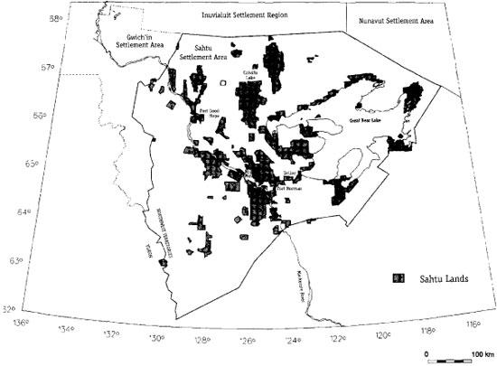
Appendix 2: Map of Sahtu Settlement Area
Appendix 3: Schedule of Capital Transfer Payment, 1994 to 1996
| Date | Capital Transfers to Sahtu Secretariat Incorporated |
|---|---|
| June 23, 1994 | $9,000,000 |
| September 6, 1994 | $3,320,037* |
| September 6, 1995 | $4,980,057* |
| September 6, 1996 | $6,640,076* |
| Total | $23,940,170 |
| * Net of negotiation loans repayments | |
Appendix 4: Implementation Payments, 1994-1995 to 1996-1997
| Fiscal Year | Implementation Payments |
|---|---|
| 1994-1995 | $688,458 |
| 1995-1996 | $1,205,791 |
| 1996-1997 | $1,622,443 |
| Total | $3,516,692 |
| Note: These amounts include payments to SSI, GNWT and the Implementing Bodies. | |